Wednesday turned out to be quite a day. We got up at 6:30 mountain time in Keystone, South Dakota. We drove all day, expecting to camp around La Crosse, Wisconsin for the night.
We made a side trip into Mitchell to see the Corn Palace, a building with Kremlin-style domes on towers painted in brilliant green and yellow, and the outside walls completely decorated in a mosaic depicting western scenes. The mosaic is made entirely of corn, and the scenes change periodically, or so I understand. I suspect that birds love to eat the walls, but wouldn't know for sure.
There was a street festival blocking off our access to the Corn Palace. We could drive past it a block away, but there was no way to even get a picture. Still, you can't make up something more unusual that this. Except Wall Drug, of course. We were there on Tuesday, I'll talk about it later.
Anyway, we hit the road at 7:50 AM from our campground, mountain time. By the time we got to La Crosse it was 8:45 PM, central time. We felt like we could keep going, so we zipped into the tourist information rest area, grabbed a campground guide to Wisconsin, and kept on driving. I contacted a place near Madison and they said they had spots, and we could set up and register in the morning. She warned me it was a little swampy in the second and third loops, but we could stay in the first loop. She joked that Wisconsin had been getting a lot of rain lately. We hadn't seen the news, we didn't know what was happening. We've been living in an area of the country that's on fire, for crying out loud!
We got there at 11:50 PM. Theresa and I walked through the first loop to find a spot and were amazed. The entire place was under several inches of water. There was intense lightning and thunder all around. There was no way we could drive back to any sites. We would never get out. It was insane.
We drove to a nearby gas station that was closed and took an hour nap. By then another intense thunderstorm was moving in. We had no way to camp, didn't care to buy two hotel rooms to put six people in a hotel, and didn't want to drive through Chicago during a storm during the day with all the traffic. So Theresa and I took one hour shifts and drove through the night. It was pouring so hard by the time we left the first toll booth in Rockford that you could hardly see. We rarely went faster than 50 mph, but there was almost no traffic, all the construction crews were home, and we could see our lanes without much trouble. Besides, it was just about as light as day, since the city lit up the sky so much.
I drove from the toll oasis by O'Hare through the Dan Ryan to Portage, Indiana. Despite the torrential rains and huge blasts of lightning it only took me about 30-40 minutes to get from O'Hare to the Indiana line. We kept up the one hour shifts until the kids woke up, just after 7 AM eastern time. When I bought gas in Portage we had traveled exactly 995 miles from our campground in South Dakota.
Theresa drove from about Saugatuck to home. We got here at 8:55 AM. The kids did all the unloading while I slept until 12:30 and Theresa slept until about 2. We're slowly doing laundry and some other chores, like buying groceries, getting the big box of mail from the post office, and getting the dog.
We're exhausted but home and safe. It has been an incredible trip. I'll put a few more entries up on the blog explaining some of what we did the last few days. We were gone until very late and were just too tired to do much on the internet after such full days of activities.
Back to work on Monday. I can't wait to go on vacation again.
Thursday, August 23, 2007
Tuesday, August 21, 2007
From Glacier to Laurel
We left Glacier Campground at 10 Sunday morning, filled up with gas, and headed south. Highway 83 was closed due to wildfire Thursday, but was reopened Saturday so we were able to go that direction. We had a long way to go before reaching the interstate; it took four hours of two lane road through forests and mountains before we reached the highway just before Deer Lodge. We saw lots of smoke, and lots of fire “staging areas” with National Guardsmen controlling access, but no active fires.
When we reached Deer Lodge there was a high wind and spitting rain. We decided to do McDonalds instead of making sandwiches, and took 45 minutes between our gas and food stop because “fast food” doesn’t mean fast service in Deer Lodge.
Our drive east on interstate 90 was difficult due to high crosswinds buffeting us around. We enjoyed the view as we crossed the Continental Divide past Butte (a pretty town in an industrial sort of way). Also around the divide we saw many towering rock formations interspersed in the woods, reminiscent of the campground we stayed at years ago near Butte with the “castles.”
There was an active grass fire along a ridge about 20 miles west of Laurel. We were chasing the rear of a storm and had a rainbow for about 10 minutes
We reached Laurel at about 7 and checked in to our campground. The campground was originally the camp for German POWs in WWII. There are several brick buildings in the park that were built by the prisoners. It was right across the river from an oil refinery which makes noise. According to the people next to us the noise keeps going all night. Actually, we had more noise due to the highway and train tracks next to us, but we had a decent enough night of sleep and got going early Monday toward the Black Hills. Through the smoke and fires in Montana and Wyoming.
A Few Montana Pictures
On the way to Glacier, about 11 AM on a "cloudless" day. The only clouds are due to the smoke in the air from the fires.
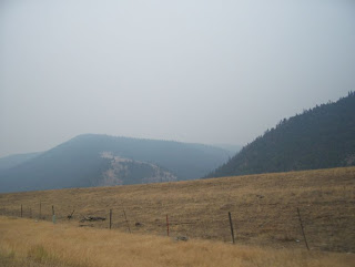
I took this picture on the way to Glacier at about noon. You can see how hazy and smoky everything was.
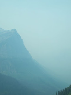
This shot looking across the valley in Glacier was taken in the middle of the afternoon. The haze is all the smoke in the air from the forest fires around the park.
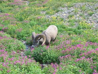
This bighorn sheep was eating the flowers right next to our trail

Friday, August 17, 2007
Montana Burning
Check the wildfire reports and you'll see that large patches of Monatna are on fire. You don't have to go online to see this if you are in Montana, however.
Yesterday when we were getting ready to leave Idaho it looked hazy and overcast. I had seen a weather report calling for a chance of rain, so we hurried to pack up and get on the road. The haze stayed with us as we drove. As we crossed the pass into Montana it started to get thicker. We could smell the smoke, like the smoke of hundreds of campfires. It was pretty obvious that we were seeing the haze of wildfires, not looming rain.
It got thicker as we moved East. Three large vans with Oregon plates passed us, heading into Montana. On their sides were "Forest Fire Brigade", on top were tooles and cans of chainsaw fuel; fifteen people were inside each van. By the time we left the freeway (33 miles into Montana), the smoke was irritating our eyes and throats. It got worse. As we drove north we had to slow down. The haze resembled the morning mist of the Blue Ridge or Smoky mountains, but this was not early morning mist. I timed visibility while driving a steady 60 mph. Less than 30 seconds, or under a half mile. The landscape looked desolate and barren, you couldn't see beyond the ridge just next to the road because the sky was so clouded with smoke. As we reached Flathead Lake there were white pieces of ash visible floating in the air. We stopped for gas and it was spooky, with ash fluttering down on us, no sun, and a strange orange glow to everything.
I asked the gas station attendant where the fire was. She laughed and said "Everywhere." A bit of an exaggeration, perhaps, but not much. We looked at the map later and there are thousands of acres on fire just east of where we were. In fact, the main US highway is closed between Missoula and the National Park because of the fires. Fortunately, we weren't going that way. We'll have no trouble with any of the existing fires during our stay here at Glacier.
What the fires are doing to our trip, however, is another thing. Views in the park are hazy. Heavily overcast, as if there's a dense fog over everything. It's very hard to see mountains, lakes, waterfalls, or glaciers. Hiking is complicated by the irritation of the smoke to our eyes and throats. Thin high-altitude air is even harder to breathe with all the smoke everywhere. It's strange, but we can still see things up close, so we're still enjoying ourselves.
Yesterday evening after supper we went into the national park to scout out the visitor centers and plan our day for today. This was a good idea, because we found a moderatly difficult hike we could do at the continental divide, which we would reach using the shuttle bus service.
To get to the Logan Pass Visitor Center you take the Going-to-the-Sun Highway. This road is incredible, a narrow ribbon of pavement that winds its way up the mountains with only one switchback. Vehicles over 21 feet long are prohibited. There are no real guardrails to speak of (one shirt we saw at a gift store says "Real Men Don't Need Guardrails"). We were glad to use the shuttle, to save our gas and our nerves. Plus we had fun talking with people from all over the world on the bus.
We planned a hike for tomorrow with the help of a park ranger at the visitor center, took the shuttle down the other side to the East side of the park, then went back to the top and took our hike. On the way back up the road was blocked by two bighorn sheep, standing there as if they owned the road.
Our hike started at the visitor center and went 1.5 miles uphill to the Hidden Lake overlook. It was a pretty steep trail in spots, but there were many Mountain Goats right next to the trail (including a mother and baby), as well as some bighorn sheep, again right next to the trail. We got some good pictures along the way. The view from the top was hazy and obscured by smoke. It's hard to get a good scenery picture in the tricky light caused by all the haze.
Our hike tomorrow is to three different waterfalls. Hoepfully there will be clearer air. The locals tell us that they can't remember fires this severe, or this much smoke. To put this in perspective, the nearest fire to us is at least 30 miles away, but when we were on the Going-to-the-Sun Highway at the end of the day we had about a tenth of a mile visibility. It was really that thick. I heard on the news as I typed this that Missoula (a hundred or so miles away?) is pretty much shut down due to the air quality alerts.
We leave here Sunday, through a pass that goes right next to an area where the fire was out of control a few weeks ago but now is "75% Contained." The pass is open and we've been assured there won't be any trouble with getting through. We'll see.
Wednesday, August 15, 2007
California and Oregon Pictures
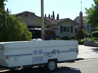
Packing to leave Heidi and Jeff's house
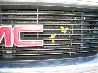
What happens after you drive through a cloud of butterlies in the Central Valley of California
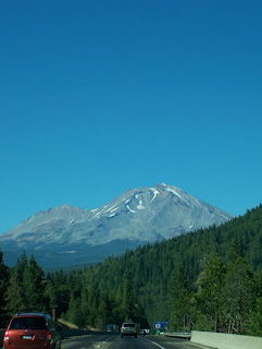
Mount Shasta in northern Californa
Where I camped in 1971, and we camped on this trip in 2007
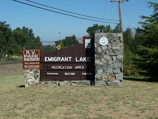
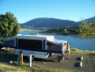
Our campsite at Emigrant Lake--2007
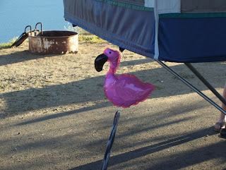
Pete the Flamingo goes with us everywhere we camp
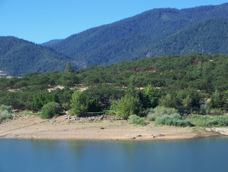
The campground we stayed at in 1971 is in the trees above the road in this picture
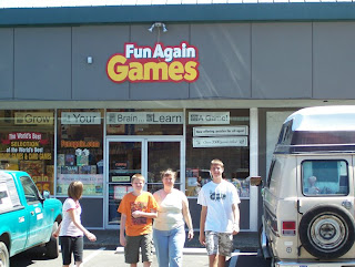
Leaving a store in Ashland

What happens after you drive through a cloud of butterlies in the Central Valley of California

Mount Shasta in northern Californa

Where I camped in 1971, and we camped on this trip in 2007

Our campsite at Emigrant Lake--2007

Pete the Flamingo goes with us everywhere we camp

The campground we stayed at in 1971 is in the trees above the road in this picture

Leaving a store in Ashland

Slight Change of Plans
Theresa has a cold. Her voice was pretty much gone by Sunday night, and it didn't get much better Monday. Jeanette was not feeling well Monday either. Consequently, we decided to take it easy on Tuesday, and skipped our Crater Lake excursion. Crater Lake would have added several hours to our day, plus some hiking. So instead we took our time leaving Ashland yesterday and had a relaxing drive to Portland.
Our campground last night was a county park southeast of Portland. We were tucked in among huge old pine trees, in a very quiet area away from all the major roads. (But close enough to civilization to find gas for $2.59 a gallon!) It was a nice place to camp.
We were on the road by 9AM this morning. As we headed toward the interstate we had an impressive view of Mount Hood to the East. We drove through the Columbia River gorge, one of the most beautiful drives on any interstate highway in the country.
We got to our campground in Osburn, Idaho this evening at 5:15. It was hot today, up over 105 as we drove through Washington between Richland and Spokane. When we got here, it was still 97, but it was very comfortable in the shade. It's now quite cool since the sun went down about a half hour ago.
We don't have cell phone reception here. Tomorrow we leave for Glacier National Park, and I'm sure we won't have service there either. We might for a while on the interstate, so if you need to contact us, try calling before 6PM Eastern time. We'll be at Glacier for the next three nights. We will have internet access at our campground, but probably not phone service.
Thank you for keeping up with our trip!
You Can't Go Back Again...
In 1971 my father spent a few months over the summer taking some Geology courses at Southern Oregon College in Ashland, Oregon. Our family lived in Ashland for much of the summer, and as we were planning our 2007 road trip I thought it would be fun to stop in Ashland and see if I could find things I remember.
Back in 1971 we spent the first week or so of our time in Ashland staying at Emigrant Lake, camping at an Army Corps of Engineers site. When I started planning our '07 trip I saw that the county now manages a full-fledged RV Campground at Emigrant Lake. Of course, I reserved a site.
As we pulled in I immediately recognized the lake. It is a reservoir, with steep sloping banks and an irregular shape. It seemed much smaller than I remember it, but as we drove in I saw the exact sites where we had camped in 1971. They have no hookups, and they're too steep and small for modern RV's (big motor homes), so the county had a new campground on the far end of the lake. It was right next to a beach of huge reddish rocks. If my brother reads that last sentence he'll know exactly what I mean, because he and I spent hours exploring those rocks from our canoe. I'm sure there was danger at every turnpoint back then...now we just saw the "Cougars have been spotted" sign and spent the evening making bad cougar jokes to scare Theresa.
In the morning Theresa and I drove around looking for the house we had rented after camping the first few weeks in 1971. It was gone. Not only was the house gone, but the street was gone, and the entire neighborhood was gone. What used to be a valley is now a hill, a hill covered in fake-old condos and a golf course. Ashland is now a town of 20,000 people. I suspect in 1971 that fewer than 10,000 lived there. The two lane main drag through town is now two roads, each a one way street. The library (a big old white frame house) is now part of the University (not a college) and there is a brand new library built. The mineral water fountain in Lithia Park has been removed "for restoration" and the big water fountain at the end of the park dispenses fresh city water. It was odd how things looked similar, but changed just enough to make it seem like a weird type of deja vu experience.
Subscribe to:
Posts (Atom)